What is Avera?
Avera
Avera is a cutting-edge Active Alerting System designed to enhance road saftey for all users by providing
real-time alerts about potential hazards and events on the road to users and emergency services.
By colating data from multiple sources, Avera can identify potentially dangerous traffic situations which allow our operators to react quicker.
Ultimatly keeping our roads safer for everyone.
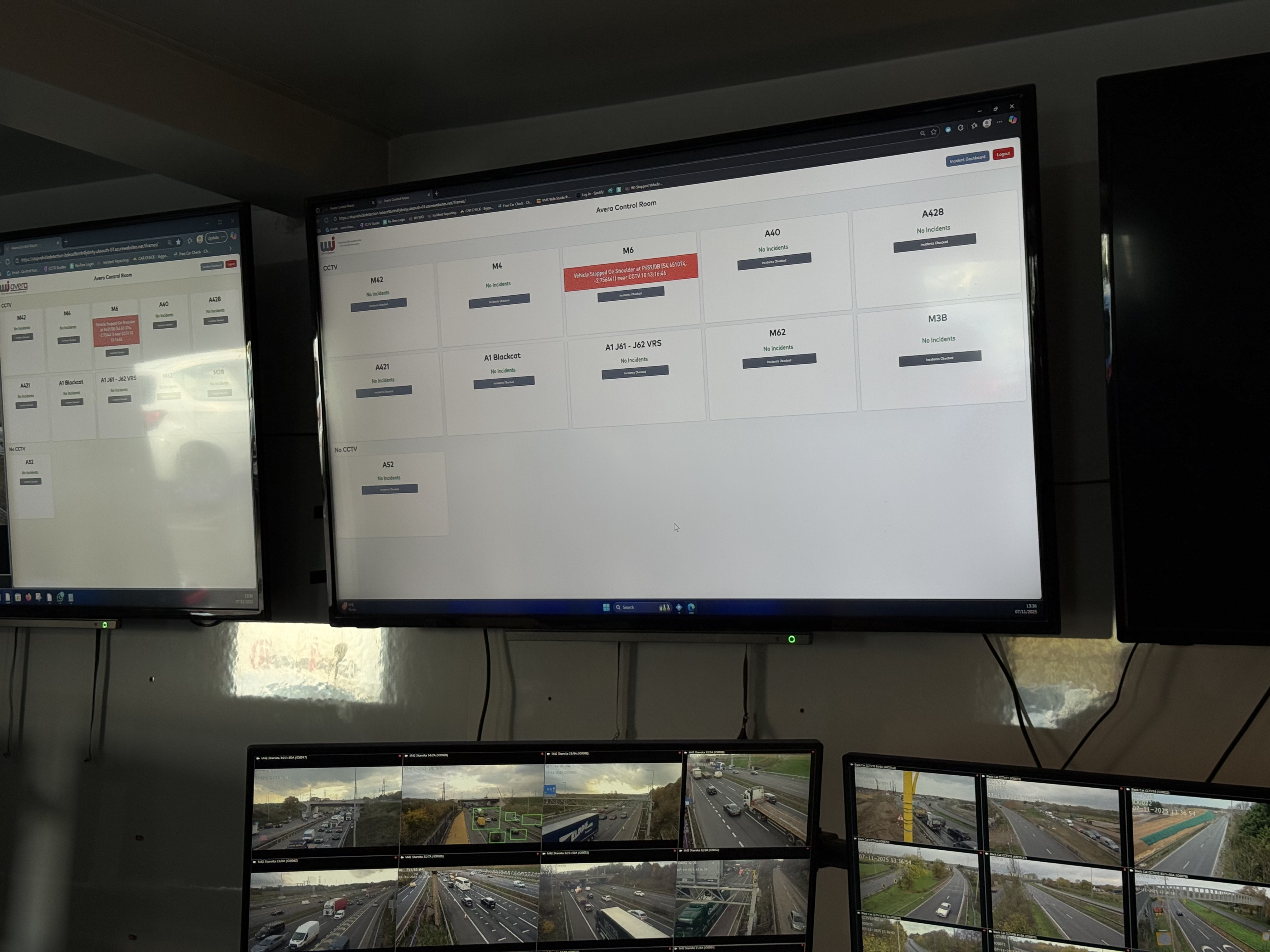
Avera provides operators with real
time situational awareness,
automatically identifying stopped
vehicles and potential hazards, even
in areas with limited CCTV coverage.
What we see
Live Alert Board
All schemes at a glance. Alerts bubble to
the top for immediate visibility
Scheme Overview
Maps and lists showing live and recent incidents
Analytics
Compare detection lead/lag, monitor
incident counts and review average speeds
Exports
Generate downloadable incident
summaries for audit and reporting
Use Cases
Temporary Works Monitoring
With CCTV
Without CCTV
M4 J37/38
Avera can also be used to monitor temporary works where the budget may not allow for CCTV coverage.
By colating data from multiple sources traffic incidents can be identified by operators in real time allowing them to get the appropriate resources to the incident in a shorter amount of time.
Avera was used to monitor the M4 J37/38 temporary works for a month, to see how it would effect recovery time.
Our Findings
During this month we identified a total of 73 Incidents that where present on the scheme.
We estimate that the use of Avera caused recovery times to be reduced by 20% on average, with some incidents being cleared up to 40% quicker than normal.
Diverson Monitoring
A47 Tuddenham – Full Weekend Road Closure Diversion Route Review
Using the Situation–Task–Action–Result–Transfer (START) format
Avera can be used to monitor the saftey and the effect that diversions have on traffic flow.
Using data sources such as Average Speeds, Journey Times, and Delay Times we can build a picture of
how the diversion is affecting traffic and identify any potential issues that may arise if the diversion was inplace again.
1. Situation
Galliford Try collaborated with WJ Group to trial Avera, a new data driven road network monitoring system.
Avera uses open source traffic data to detect issues on live networks, originally designed as an alternative to CCTV for identifying breakdowns within roadworks.
The A47 at Tuddenham required full weekend closures in November and February, with traffic diverted via the pre agreed diversion route.
To ensure the diversion route performed effectively and safely, and to assess the system’s wider potential, Galliford Try and WJ undertook a comprehensive data trial.
The goal:
-
Understand the true impact of the closures on journey times, delays, and incidents.
-
Evaluate whether Avera can reliably monitor performance and identify hotspots or risks.
-
Identify improvements for future closures.
2. Task
The team set out to achieve the following:
-
Capture full data sets for both closures and the following weekends when the A47 was open.
-
Analyse journey time, speed, and delay patterns along the full diversion route.
-
Identify incident hotspots, including stopped vehicles and suspected collisions, using Avera’s detection capabilities.
-
Compare weekend-closure performance against baseline (non closure) conditions.
-
Assess Avera’s suitability as an operational tool for:
-
Traffic management
-
Detecting breakdowns or incidents
-
Monitoring diversion route effectiveness
3. Action
Data Collection Using Avera
Avera captured live, open source traffic information throughout:
-
November closure 15-16 November 2025
-
Following period 13 November - 16 December 2025
-
February closure 13-16 February 2026
-
Following weekend 20 - 23 February 2026
Metrics collected:
-
Journey times
-
Average speeds
-
Delay times
-
Stopped-vehicle events
-
Suspected RTCs (based on abnormal traffic behaviour)
-
Incident Mapping and hotspot identification
Comparative Analysis
Avera captured live, open source traffic information throughout:
-
Diversion route performance during closure vs when A47 is open
-
Traffic speeds and delays
-
Volume and distribution of incidents
-
Changes in driver behaviour and route stress points
System Learning Improvements
Between the two closures:
-
Avera’s approach was refined based on earlier findings
-
Data capture and incident detection were improved.
-
Additional behavioural and environmental indicators were explored, such as:
-
Harsh braking/acceleration
-
Harsh Cornering
-
Near Misses
-
Speed Variance
-
Surface friction, IRI, Standing water, and Weather inputs
4. Result
Key Findings For November
| Metric |
During Closure |
A47 Open |
| Average Journey Time |
69 mins |
71 mins |
| Average Delay |
6.7 mins |
9.3 mins |
| Incidents |
37 Stopped Vehicles, 4 Suspected RTCs |
Insights:
-
Journey times remained stable or improved slightly under clousre conditions.
-
Delay times were lower during clousrue than during the open-road baseline.
-
No abnormal rise in incident rates.
Key Findings For February
| Metric |
During Closure |
A47 Open |
| Average Journey Time |
68 mins |
78 mins |
| Average Delay |
6.2 mins |
5.2 mins |
| Incidents |
55 Stopped Vehicles, 5 Suspected RTCs |
92 Stopped Vehicles, 11 Suspected RTCs |
| Average Speed |
48 mph |
51 mph |
Insights:
-
Journey times were identical whether the A47 was closed or open
-
Delay increased slightly under closure, but remained relatively low.
-
Post closure weekend recorded significantly more incidents than the diversion weekend.
-
Average speeds dipped only marginally during closure.
Overall Conclusions
-
The diversion route coped very well with the aditional volume.
-
The closures had minimal impact in journey times and speeds.
-
No meaningful increase in collisions or breakdowns during clousure.
-
Performance consistencey suggests effective comms and signage.
-
Avera proved capable of caputuring and analysing traffic performace without fixed CCTV.
5. Transfer (Learning for Future Use)
How Avera Supports Future Closures
This trial demonstrates that Avera can be used to:
-
Monitoor diversion route effectivness in real time.
-
Identify incident hotspots and risk areas.
-
Detect stopped vehicles and abnormal traffic flow.
-
Highlight behavioural trends such as harsh breaking and cornering.
-
Infrom mitigation strategies and resource deployment.
Future Applications
-
Better identification of rat-running (currently limited by low volumes on side roads).
-
Enhance pre-closure modelling using Avera's behavioural and environmental indicators.
-
Targeted mitigation at hotstops identified on the A11 and local roads.
-
Continuous improvement of diversion route design and signage effectiveness.
Next Steps
-
Continue refining Avera's detection and analytical capabilites.
-
Intergrate additional behavioural and environmental data layers.
-
Apply lessons learned to upcoming closures.